2012. 8. 18. 15:44ㆍ구글강좌
[퍼온글] 구글 지도에서 전 세계 100만곳 이상의 대중교통 정거장 시간표를 확인할 수 있습니다.(구글코라이블로그)
작성일: 2012년 8월 16일 목요일
구글 지도에서 이제 한국을 포함해 전 세계 500개 이상 도시의 대중교통 정보를 볼 수 있습니다. 정거장별로 대중교통 시간표, 목적지까지의 대중교통 경로, 정류장 정보를 볼 수 있습니다.
이러한 대중교통 정보는 특히 손 안에 가지고 다닐 때 유용합니다. 오늘 소개해 드릴 안드로이드용 구글 지도(6.10버전) 업데이트로 휴대폰에서 편리하게 대중교통 정보를 볼 수 있습니다. 대중교통 정보는 버스, 지하철 등 교통 수단별로 확인할 수 있어 모바일 지도에서 편리하게 필요한 정보를 확인할 수 있습니다.

전체 교통 정보 모바일 지도

지하철만 선택
또한 정거장 이름을 터치하면 정거장 정보 페이지로 바로 연결 되며, 이외에도 다음과 같은 기능이 업데이트 되었습니다.
? 도시나 우편번호를 찾을때 그 지역의 경계가 지도상에서 강조되어 보입니다.
? 내 장소에 추가된 탭에서 저장된 지도나 별 표시한 장소, 내 지도 등 지도 관련한 내 모든 정보를 한번에 볼 수 있습니다.
? 위치 기록를 활성화 하면 위치 기록 대시보드에서 내가 찾았던 장소를 한눈에 볼 수 있습니다.
대중교통 시간표와 요금, 근처 역 정보를 구글 지도에서 확인해서 편리하게 대중교통을 이용해 보시기 바랍니다. 구글 플레이 스토어에서 최신 버전 안드로이드용 구글 지도 애플리케이션을 받을 수 있습니다.
출처 : 구글코라이블로그
http://googlekoreablog.blogspot.kr/2012/08/100.html?utm_source=feedburner&utm_medium=feed&utm_campaign=Feed:+blogspot/vCGH+(Official+Google+Blog+-+Korea)
Google Maps now has schedules for more than one million public transit stops worldwide
August 16, 2012
Since 2005, we’ve collaborated with hundreds of transit authorities around the world to make a comprehensive resource for millions of riders to find out which bus, train, subway or tram can take them to their next destination. Today, Google Maps has public transportation schedules for more than one million transit stops worldwide, in nearly 500 cities including New York, London, Tokyo and Sydney.
Public transportation information is especially useful when it’s in the palm of your hand. Today we’re releasing an update to the Google Maps for Android app (version 6.10) which makes this transit information even more useful. We’ve made some changes to the Transit Lines layer, so that you can select a specific mode of public transportation (train, bus, tram or subway) to display on the mobile map, hiding the other modes. This is helpful in areas where there is a tight concentration of several types of public transit.

Left: Mobile map with all modes of public transit shown; Right: Transit Lines layer in Subway mode
We’ve also updated the layout of station pages to be more useful. Open it by tapping on the name of the station on your mobile map.
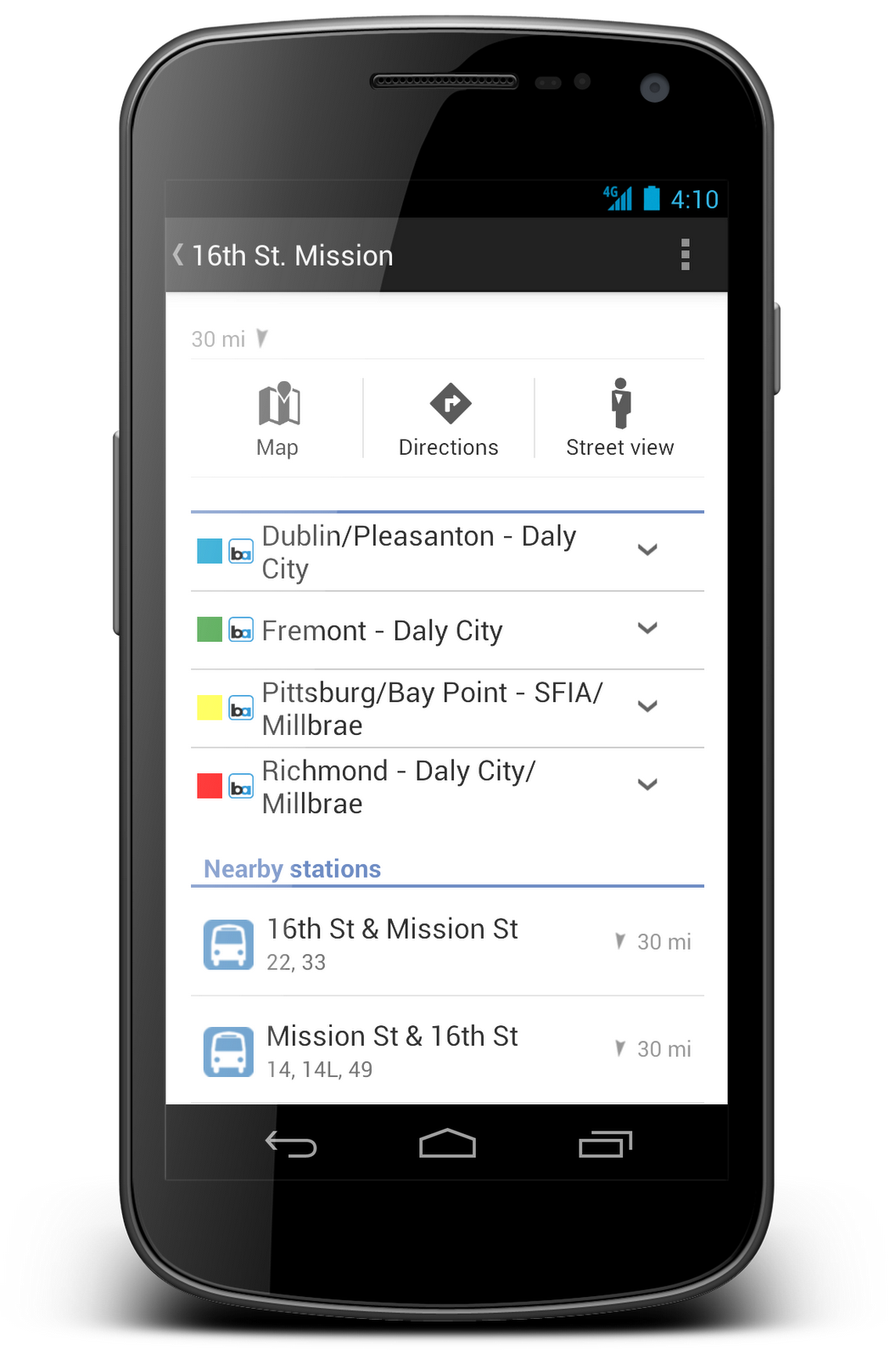
Updated station pages show you departure times, lines serving the station and the distance to nearby stations.
In addition to these new transit features, we’ve updated region highlighting, My Places and Location History displays in Google Maps for Android:
? Now, whenever you search for a city or postal code, the borders of that region are highlighted.
? Under My Places you’ll notice we’ve added new tabs, which will help you access all your information from a single place; from your saved maps for use offline to your starred places and Custom Maps created on your desktop.
? If you enable Location History, you’ll be able to browse the places you’ve been on a daily basis with an updated Location History dashboard.
Whether you’re looking for schedule and fare information, directions by public transit or nearby stations, Google Maps puts comprehensive, accurate and useful transit information at your fingertips. Update to the latest version of Google Maps for Android in the Google Play store.
Posted by Christopher Van Der Westhuizen, Software Engineer, Google Maps
'구글강좌' 카테고리의 다른 글
| [구글워크14] 페이지 제목으로 검색하기 (1) | 2012.08.20 |
|---|---|
| 구글 핸드라이트는 손글씨로 검색하는 도구이다. (3) | 2012.08.19 |
| [구글워크13] 특정도메인이나 웹사이트에서만 원하는 정보을 검색하고자 할 때 ➅ (1) | 2012.08.18 |
| [구글워크12] 구글앱스에 대한 파워포인트문서을 찾고 싶을 때(특정파일을 검색하고자 할 때) (5) | 2012.08.18 |
| [구글워크09] 구글검색에서도 와일드 카드(*)을 사용한다? (3) | 2012.08.18 |